Philippines Makeover

From a distance, we ask...'tang'na, why not? Learn about our nation, then dream up a better Philippines with Google Earth, SketchUp, and all things possible in the virtual. Render a bridge. Share lessons. Take/make a tour. Bridge investors with Pinoy producers and manufacturers. Questions, visions, delusions welcome.

    Uy! Google Earth Philippines: Google Earth ekek for Pinoys!

      Monday, December 18, 2006

      :: quirino walkable district: opportunity sites

      (Cross posted on Another Hundred Years Hence.)

      Next on our urban sketch project, let's look at the opportunities for redevelopment in our proposed walkable district. (You can catch up with parts 1 and 2 of this series.)

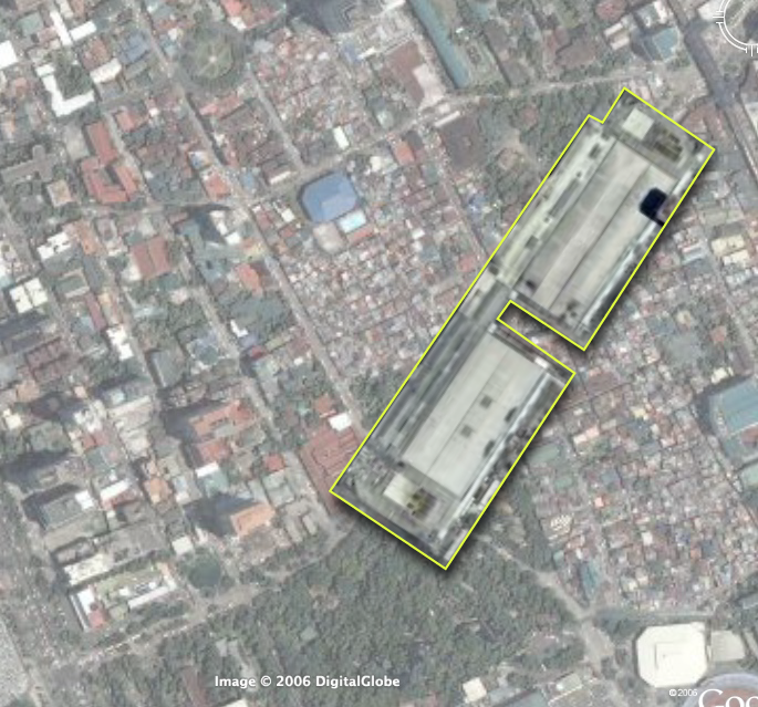
      Focusing on the middle path -right down Quirino Avenue -we find more than 8.5 hectares right along the corridor that would be ripe for redevelopment. (Click on the picture for a larger image outlining the sites, check out the opportunity sites on Google Maps or download kml file (2.1kb).)

      Also, just to give you context about the opportunity available, here are scale comparisons of the site vs. Glorietta and vs. Megamall (thumbnails after the jump).

      The eleven opportunity sites are a combination of national and local government owned land and underutilized, privately owned lots. The redevelopment of the area then requires government incentives and public-private partnerships.

      The largest chunks, thankfully, are in government control. The properties are also located at very strategic portions of the path. They include the two Bureau of Plant Industry (BPI) lots, the Leveriza (Manila) Children's Park and a segment of the Manila Zoo.

      The two BPI lots make up about 3.3 hectares. If zoned for an FAR* of 2.5, the lots could deliver as much 890,000 sq.ft. (82,500+ sqm.) of development to the market. The lots are ideal for transit oriented development (mixed-use, with retail on the ground floor, office spaces and three to five residential towers) - taking strategic advantage of the Quirino LRT station -and catering to Makati workers, with the CBD just 7 stops (4 on LRT-1 and 3 on the MRT) and one transfer away. The residential component (condo and apartments) could also service the housing demand from students from DLSU and the other schools nearby.

      The national government (BPI is under the Department of Agriculture) would do better to relocate the Bureau to where it could better serve its agricultural clientele -or where it could be closer to other agri research centers (like Los Banos). They could also require exactions from the sale, say by requiring that a percentage of the residential units be set aside for subsidized housing for public school teachers.

      Meanwhile, the Manila Zoo could raise much needed funds by leasing off part of its property along Quirino. They could give up about 100 feet deep of the zoo's layout and bring about 12,000 square meters to market. (This project might already by under contemplation by the Friends of Manila Zoo Foundation, as I found a 1997 EMB circular (pdf) listing an ECC for a Manila Zoo Redevelopment Project under a company called "Zoo Village Redevelopment Corp.") This would allow the zoo to raise funds and they can also elevate the zoo's civic presence by requiring the leasee to build a structural entrance to the zoo. (Which would be way better than just the current metal sign.) The lease can also provide structured parking for the zoo.

      The zoo's location at the bend of Quirino makes it ripe for a more visible structural entrance that would serve as a terminating vista, calling strollers from the corner of Qurino and Taft to walk down to the bend and the zoo entrance. The new entrance would neatly bisect our proposed pedestrian path -and serve as a waypoint from the LRT station to the bay and the baywalk.

      Manila City could also raise funds and improve the services of the children's park by leasing off the property but requiring the lessee to set off the majority of the lot for a much improved children's park. The lessee can also be required to maintain the park freeing the city of the maintenance costs.

      Likewise, Ospital ng Maynila could raise operational funds by leasing off its Quirino edge and its parking lot fronting the bay. They could require the lessee to provide structured parking for the hospital.

      The rest of the opportunity sites are probably privately held properties and include a large empty lot (since the Google Earth image is at least a year old, the propery may not be vacant anymore), a motel, a possible defunct water storage facility and two large underutilized properties that currently house a gas station and some nominal office spaces.

      The city government could provide incentives for redevelopment of these particular properties.

      Here's a rundown of the sites.

      Site
      est. area (m2)
      1. Bureau of Plant Industry 20,000
      2. Bureau of Plant Industry 2 13,000
      3. Empty lot 2,800
      4. Manila Children's Park 12,500
      5. Manila Zoo Edge 12,000
      6. Motel 4,600
      7. Ospital ng Maynila Edge 2,750
      8. Ospital ng Maynila Parking Lot 3,800
      9. Underutilized property 1 6,500
      10. Underutilized property 2 4,800
      11. Water storage facility (?) 2,100


      Images on the left: the area compared to Glorietta (top) and Megamall (bottom). Click for larger versions.

      What's missing:

      If this were a full urban planning study, we would do well if we had:
      1. the zoning map for the area
      2. a property list along with a cadastral or tax assesment map
      3. current pictures of the existing buildings on the sites
      Next up: Streetscape and a massing and volume study.

      *Floor Area Ratio (also called Floor Space Index) = (Total covered area on all floors of all buildings on a certain plot) / (Area of the plot)

      Monday, December 11, 2006

      :: quirino walkable district: nodes and paths

      (This entry cross posted at Another Hundred Years Hence.)

      Getting back to our urban planning sketch (part 1 here), one way to think about walkable districts is to think of nodes and paths. (This is pretty much a Kevin Lynch approach.)

      Nodes are centers of activity - paths are...well, paths that connect the nodes. Nodes also tend to define the area around the node -turning the area into a "district" of sorts. Nodes can center around a single significant building or can be formed by a cluster of activities.

      Paths of the other hand, have the power to define the edges of districts.

      I've picked out the key nodes in our project area and the paths that connect them. It's important to think of nodes when planning walkable districts as the nodes serve as destinations and define the types of activities in the walkable district. The nodes also define the character of the paths - who uses the paths and what time of the day the path will be most used.

      So our project area (which I am defining as the area loosely bound by the two transport nodes of the Quirino and the Vito Cruz LRT stations - and then the area west from the stations to the Bay), has several clusters of nodes -with different activities. (Click on the picture for a larger image or download the highres version here (png 3.3Mb) or download the kmz (164kb) file -with image overlay -here.)

      The nodes and their surrounding activities include:
      1. The north cluster with:

        The Malate Church -with its public park foreground -and the park bordered by all day restaurants
        Remedios Circle -which is actually a barely used public park -also surrounded by restaurants -most of whom provide active nightlife to the area (UPDATE: Citizen of the World has great pics of the new Remedios Circle, and he links to Bong Austero's musings on the redesigned park), and
        the San Andres Public Market

      2. A middle cluster defined by:

        The Manila Zoo, and
        The Leveriza Children's Park (formerly Paraiso ng Batang Maynila)

      3. A south cluster with:

        The Rizal Memorial Sports Center - which also serves as a concert venue apart from sports center
        Harrison Plaza (a shopping center)

      4. Several other important destinations at the very edge of the district:

        The Metropolitan Museum
        The Manila Yatch Club
        The Cultural Center of the Philippines complex (including the FAT and the PICC)

      Another major destination is, of course, the Bay itself.

      Three possible pedestrian corridors (green lines) serve these clusters.
      1. A northern path from Quirino Station to Malate Church via San Andres Road (with a branch that turns north to Remedios Circle)
      2. A middle path from Quirino Station to the Bay right past the Zoo and the Children's Park (along Quirino Avenue)
      3. A southern path from the Vito Cruz Station -right up Vito Cruz St. to the CCP complex.
      There are two other signficant pedestrian corridors:
      • M. Adriatico St. between Vito Cruz and Quirino (connecting Rizal Memorial and Harrison Plaza to the Zoo and the Park)
      • Roxas Boulevard (does Baywalk stretch all the way to here?) at the western edge of the district
      I've color-coded the nodes -green for parks, blue for cultural (including sports), and red for commercial.

      There are other ways to classify the nodes that will help us think about the activity patterns. The zoo and the park are daytime activities -while CCP, FAT and the Sport Center serve daytime activities with surge activities (major concerts and sports events) in the evening and on weekends.)

      Ideally we should also have the numbers on how many people go to these nodes (both during regular hours and during surge events).

      The activities, the hours, the number of people will tell us what other facilities we need in the area if we are to serve a pedestrian audience.

      It's also important to consider major traffic thoroughfares (in gray) bisecting the study area, which in our case (and by order of traffic volume) are:
      • Roxas Boulevard
      • Taft Avenue
      • M. Adriatico
      • F.B. Harrison
      Although Quirino (east-west) does carry some load, significant traffic flows mainly along the these north-south arterials.

      (Next up, Opportunity Sites.)

      Thursday, November 30, 2006

      :: creating the quirino walkable district:
      an urban planning sketch

      (cross posted from Another Hundred Years Hence)

      Roby's original intent with the Philippines Makeover blog was to inspire people to use Google Earth and SketchUp to reimagine our cities. I am finally indulging him (and myself) with a sketch study on creating a walkable district using Quirino LRT station as the epicenter -with Quirino Avenue as the axis and the southern Malate district as the study area. I'd like to explore how we can improve this part of the city by making it more walkable -and hopefully, more livable.

      Click on the image to the right to see a larger view of the study area. You can also see the area and the markers on Google Maps. If you prefer, you can download the kmz file for viewing on Google Earth.

      Why the Quirino Station? I don't know. It seemed a good a choice as any but what appealed to me was it's proximity to several urban amenities (the zoo, the bay, the sports center, remedios circle, leveriza children's park, etc.). The stretch of Quirino between Taft Avenue and Roxas Boulevard also presents some very interesting opportunity sites.

      I am doing this urban planning sketch...
      1. as a thought experiment, to see what possibilities there are
      2. as a model/instigation to hopefully jumpstart other flights of imagination
      3. as a showcase of physical urban planning -to show what comes into play and into consideration when you plan an area (i.e. -the physical designs, the policy approaches and the community consensus building)
      A blogpost is a limited medium when it comes to illustration so I will try to create a pdf version of each post complete with maps and diagrams.

      So we start with the walking shed. A normal, healthy person can comfortably cover 1/4 of a mile during a 5 minute walk and 1/2 a mile during 10 minute walk. (The number is awkward when translated into kilometers -but if you want the figures: 5 minutes = 0.402336 km or 400+ meters; 10 minutes = 804672 km or 800+ meters.) That radius has been the basis for the design of neighborhoods since Clarence Stein and Henry Wright proposed the plan for Radburn, New Jersey. (If the Radburn plan looks familiar to you, whip out your Google Earth and navigate to Philamlife Subdivision. Philam as well as most of the QC Projects were patterned after the Radburn/Garden Cities template.)

      The following landmarks are within a 10 minute walk radius of the Quirino LRT Station:
      • The bars in malate
      • The Remedios Circle
      • The San Andres Market
      • Malate Church
      • The Manila Zoo
      • The Leveriza Children's Park
      • Ospital ng Maynila
      • Harrison Plaza
      • The Rizal Sports Complex
      • DLSU, Benilde, St. Scho and PCU
      and just a little further off:
      • The MET
      • Bangko Sentral
      • The Manila Yacht Club
      • The Army-Navy Club
      • UP Manila
      • PGH
      • NBI
      • The Supreme Court
      • Robinson's Malate
      So you see, the walkshed has a lot of promise.

      I'd like to fill up this map with as much data as I can and gather as many landmarks as I can place within the walkshed, so if you have the time and GoogleEarth skills, churn out markers on places / landmarks (restaurants, shops, offices, etc.) within the walkshed and send us the kmz files.

      Digital copies of barangay maps of this district would also be very helpful.

      Next up: opportunity sites within the walkshed.

      Monday, July 10, 2006

      :: confluences and waterfronts


      above conceptual map of metro manila with
      suggested areas to celebrate the waterfront.


      below four opportunity sites at the confluence
      of the pasig and the san juan rivers


      (Cross posted from Another Hundred Years Hence)

      So how do we reconnect to our bay, our lake and our rivers? How do we bring them back into our shared imaginations of our cities?

      To do that, we have to celebrate our rivers, our lake and our bay. We have to celebrate them as places -and with places. Physical places where we can see and approach the water. Where the waters can reclaim their rightful place in our imagination.

      Fortunately for us, waterfronts offer some of the easiest areas for redevelopment -specially in old industrial cities.

      Cities all over the world have rediscovered and reinvested in their waterfronts. Check out False Creek in Vancouver, or London's Canary Wharf (also this), or Singapore's Boat Quay, or the Cambridgeside Galleria in Cambridge, Massachusetts -all of these were former decrepit industrial sites that were redeveloped by public and private funds, through the creation of innovative policy tools and investment vehicles.

      We've started on that road somewhat -with Marikina's Riverbanks, and Manila's Baywalk. Hopefully, the expansion of Rockwell into the old Noah's Ark Sugar factory property and the old Colgate-Palmolive factory will incorporate riverfront access. So too, I hope, Ayala's redevelopment of the Sta. Ana racetrack.

      If I had my druthers, I would turn the whole stretch of the pasig from the bay to the palace into a "riverwalk" -anchored on one end by the Intramuros and Fort Santiago and by Malacanang on the other -with the Arroceros Forest Park and a re-oriented Liwasang Bonifacio as gems in between. (Why hasn't anyone redeveloped Quiapo Ilalim?)

      I looked through Google Earth and identified at least 14 brownfield opportunity sites along the Pasig - notably at it's confluences with the San Juan and the Marikina -that are ripe for redevelopment. (Apart from the the manila oil depot -which really should move out of the city.)

      Four are right at in Sta. Ana and Sta. Mesa -on an interesting loop of land where the San Juan meets with the Pasig (see picture to the right). There are large swaths of land in Mandaluyong and Makati, along the banks of the Pasig near EDSA, and then even more right where the Marikina meets the Pasig. There are sites just east of C-5 and more south of Eastwood City (which, incidentally made the mistake of turning its back on the river.)

      I do not know how productive these properties are currently, but they would be great to redevelop into mixed-use, commercial, business and residential properties. The concerned cities should reassemble these lands - invest in the demolition and remediation (clear up any toxic messes) -then create public-private reinvestment companies to redevelop the sites. The tradeoffs (in return for the public investment) should be that the redevelop sites should set aside the waterfront for publicly accesible parks or public open spaces and that a percentage of the residential development should be affordable housing.

      I've posted the 14 sites I selected on Google Earth Philippines where you can download the kml file. Or you can view the sites via Google Maps.

      P.S.

      "What about the pollution?" you say. "Have you smelled the Pasig?" - Well one of the things we've discovered about redeveloping waterfronts -of placing parks next to the water -is that it only increases awareness and concern for the state of the rivers and lakes. The redeveloped sites become valuable opportunities (and venues) for educating the public about water -and the role it plays in our lives. (See this project in Chengdu, China.)

      The redeveloped sites could also be required to build in passive (or active) water treatment or bioremediation facilities such as living machines. (See also this example and this one.)

      (If you spot other places for redevelopment, send your kml file to Google Earth Philippines.)

      Saturday, July 08, 2006

      :: Five Roads I'd Like to Redesign

      There are at least 5 roads in Metro Manila that I'd like to re-imagine and redesign, namely:
      1. Commonwealth Avenue (R-7)
      2. Quezon Avenue / Espana (R-7)
      3. Ortigas Avenue (R-5A)
      4. Sucat Road
      5. Alabang-Zapote Road
      (Download the kml file via Google Earth Philippines. or view it on Google Maps.)

      There is so much we can do to make them work and look better -make them more pedestrian and bike friendly -and they will contribute to the a more livable urban environment.

      As wrote about rethinking our streets before, in Another Hundred Years Hence. (See also this and this.)

      What can these streets be? I've cribbed the great images from the Livable Cities presentation of the American Institute of Architect's Center for Community by Design (Get the powerpoint presentation here 1,792 KB - and the PDF here 1,769 KB).

      The pictures and text below are all from AIA. Click on the images for a larger version.

      Here you have a typical strip commercial development. This image is from Hawaii but it could be Anywhere. This is clearly a car-oriented landscape with narrow sidewalks, a wide roadway and buildings set far back.
      In this image, four key streetscape improvements have begun to change this to a pedestrian-oriented landscape.
      1. The sidewalks have been widened with landscape buffers to protect pedestrians from traffic;
      2. The buildings have been brought forward towards the sidewalk and retail has been added the first floors to create an interesting place for people to walk along;
      3. A bike lane has been added to the road to accommodate cyclists and provide another transportation choice;
      4. A median is included to reduce the perceived width of the road and facilitate pedestrian crossings.
      On the far side of the street, they’ve added mid-rise residential buildings with more retail on the ground floor. This mix of uses promotes neighborhood activity at all hours of the day.
      By adding trees and landscaping, the street becomes a pleasant, shady place to stroll. Also notice another building in the background has been added. Infill development helps to preserve urban centers.
      This image shows an alternative way to create a human-scaled street. Here, the bike lane is separated from thru-traffic and brought in with a local circulation lane for shoppers. The retail is still pedestrian-oriented and the angled parking serves a buffer from traffic.
      I see no reason why we can't do this. And we can argue about the effects this will have on traffic.

      For more images and like those above, visit Urban Advantage.

      Friday, July 07, 2006

      :: a river runs through it

      (Cross posted from Another Hundred Years Hence)

      Maynila
      was born on the banks of the Pasig -established by people who were taga-ilog ("river folk") and yet 600 years later, we are so disconnected from our bodies of water.

      Notice my conceptual map - I know the Pasig connects the Bay to the Lake and I know it runs north of Makati and South of QC, San Juan and Mandaluyong - but I am, as I suppose the majority of us are, not aware of its eastward route. I have no mental image of how it meets the Laguna de Bay.

      I have no mental image of the shores of the lake. I have a memory of driving around the lake -but not at the water's edge.

      I know the San Juan River and Marikina River feed into the Pasig -but also have no mental image of where these rivers meet. I know the Manggahan floodway separates from the Marikina River at the Napindan Floodgates -and the floodway then runs straight towards the bay. I also know that the Tullahan feeds into the Bay and somewhere down south, the Paranaque River also feeds the Bay.

      Why am I not aware of the paths of these rivers? Mainly because so few landmarks and public spaces are on the waterfront. Baywalk and the reclamation area face the bay. The Senate, the Cultural Center, the Folk Arts Theatre and the Coconut Palace are on the waterfront. So too the Quirino Grandstand in Rizal Park. The Malacanang is on the Pasig. The Jones, Macarthur, Quezon and the Ayala bridge over the river near Quiapo and Escolta.

      Apart from that, very little of our urban life is connected to the water. So the rivers are dead -not just biologically, but also in our imaginations. The rivers do make their presences felt when they overflow their banks.

      There are efforts to revive the Pasig and the return of the ferry will help -but until we reclaim the waterfront as public space, our waterbodies will live outside our conception of our metropolis.

      (You can download a kmz file of the metro's major rivers on Google Earth Philippines or you can view it on Google Maps.)

      Thursday, July 06, 2006

      :: Mass Transit I'd Like to See

      Here's something I'd like to see QC take on as a city project: a series of bus rapid transit / or tram (surface light rail) lines connecting employment and commercial centers in the city.
      Click on the picture for a larger image, or see it on Google Maps. You can also download the kml file from Google Earth Philippines, via this link.
      I've chosen mostly wide roads on routes that are not directly served by (a single) jeep or bus route.)
      I see at least 4 lines.
      1. RED - UP to Quiapo via Quezon Ave. and Espana (potentially the most politically difficult because of exisiting jeep and bus routes -and the planned LRT line 7 -but I think QC should go ahead with it anyway)
      2. BLUE - From North Triangle to UP via Ortigas CBD and Eastwood/Libis
      3. YELLOW- Cubao to Eastwood/Libis Loop
      4. GREEN - Cubao to Munoz via Congressional and Visayas Avenues.
      These should preferably be on dedicated lanes and fixed tracks -but at grade. Narrower roads can be reserved for exclusive use of the bus/trolleys (except for local residents).
      Pictures below show what they could look like.
      (Check out my latest post at Another Hundred Years Hence to see the logic behind these connections.)