:: Five Roads I'd Like to Redesign
There are at least 5 roads in Metro Manila that I'd like to re-imagine and redesign, namely:
- Commonwealth Avenue (R-7)
- Quezon Avenue / Espana (R-7)
- Ortigas Avenue (R-5A)
- Sucat Road
- Alabang-Zapote Road
There is so much we can do to make them work and look better -make them more pedestrian and bike friendly -and they will contribute to the a more livable urban environment.
As wrote about rethinking our streets before, in Another Hundred Years Hence. (See also this and this.)
What can these streets be? I've cribbed the great images from the Livable Cities presentation of the American Institute of Architect's Center for Community by Design (Get the powerpoint presentation here 1,792 KB - and the PDF here 1,769 KB).
The pictures and text below are all from AIA. Click on the images for a larger version.
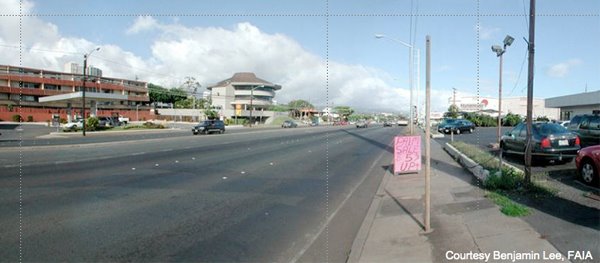
Here you have a typical strip commercial development. This image is from Hawaii but it could be Anywhere. This is clearly a car-oriented landscape with narrow sidewalks, a wide roadway and buildings set far back.

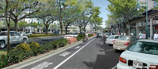
In this image, four key streetscape improvements have begun to change this to a pedestrian-oriented landscape.
- The sidewalks have been widened with landscape buffers to protect pedestrians from traffic;
- The buildings have been brought forward towards the sidewalk and retail has been added the first floors to create an interesting place for people to walk along;
- A bike lane has been added to the road to accommodate cyclists and provide another transportation choice;
- A median is included to reduce the perceived width of the road and facilitate pedestrian crossings.

On the far side of the street, they’ve added mid-rise residential buildings with more retail on the ground floor. This mix of uses promotes neighborhood activity at all hours of the day.

By adding trees and landscaping, the street becomes a pleasant, shady place to stroll. Also notice another building in the background has been added. Infill development helps to preserve urban centers.
This image shows an alternative way to create a human-scaled street. Here, the bike lane is separated from thru-traffic and brought in with a local circulation lane for shoppers. The retail is still pedestrian-oriented and the angled parking serves a buffer from traffic.I see no reason why we can't do this. And we can argue about the effects this will have on traffic.
For more images and like those above, visit Urban Advantage.
posted by Urbano dela Cruz @ 9:58 AM
![]()
![]()

1 Comments:
Good luck with Alabang-Zapote Road. The improvement I'd like to see on that road is to make it 6 lanes instead of 4. But that won't happen since the gov't would be spending billions to buy the right-of-way.
The four lanes would not be much of a problem if only Las Pinas had better public alternate routes. But as it is, if you want to go from the eastern end of the city to the western part or vice versa, you almost have no choice but to slog through the traffic along A-Z Road.
The Friendship Routes program initiated by the local government mitigate the problem somewhat, but it's not enough.
In this regard, A-Z Road is the worst among all major streets in Metro Manila. I figured that this was a result of poor planning back in the late 70's to early 80's. Like most other rural towns, there is only one major road passing through the town. Residential developments claimed the land space and prevented the construction of orthogonal and parallel roads to anticipate the urban development (something the Ayalas did in Makati).
I'm fearing that the same thing would happen to the other suburban towns in the Philippines. Paranaque had the same problem as Las Pinas, but the former was able to make Sucat Road into a six-lane street with a center island to boot!
Post a Comment
<< Home