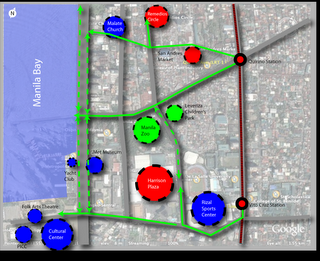
:: quirino walkable district: nodes and paths
 (This entry cross posted at Another Hundred Years Hence.)
Getting back to our urban planning sketch (part 1 here), one way to think about walkable districts is to think of nodes and paths. (This is pretty much a Kevin Lynch approach.)
Nodes are centers of activity - paths are...well, paths that connect the nodes. Nodes also tend to define the area around the node -turning the area into a "district" of sorts. Nodes can center around a single significant building or can be formed by a cluster of activities.
Paths of the other hand, have the power to define the edges of districts.
I've picked out the key nodes in our project area and the paths that connect them. It's important to think of nodes when planning walkable districts as the nodes serve as destinations and define the types of activities in the walkable district. The nodes also define the character of the paths - who uses the paths and what time of the day the path will be most used.
So our project area (which I am defining as the area loosely bound by the two transport nodes of the Quirino and the Vito Cruz LRT stations - and then the area west from the stations to the Bay), has several clusters of nodes -with different activities. (Click on the picture for a larger image or download the highres version here (png 3.3Mb) or download the kmz (164kb) file -with image overlay -here.)
The nodes and their surrounding activities include:
- The north cluster with:
The Malate Church -with its public park foreground -and the park bordered by all day restaurants
Remedios Circle -which is actually a barely used public park -also surrounded by restaurants -most of whom provide active nightlife to the area (UPDATE: Citizen of the World has great pics of the new Remedios Circle, and he links to Bong Austero's musings on the redesigned park), and
the San Andres Public Market - A middle cluster defined by:
The Manila Zoo, and
The Leveriza Children's Park (formerly Paraiso ng Batang Maynila) - A south cluster with:
The Rizal Memorial Sports Center - which also serves as a concert venue apart from sports center
Harrison Plaza (a shopping center) - Several other important destinations at the very edge of the district:
The Metropolitan Museum
The Manila Yatch Club
The Cultural Center of the Philippines complex (including the FAT and the PICC)
Three possible pedestrian corridors (green lines) serve these clusters.
- A northern path from Quirino Station to Malate Church via San Andres Road (with a branch that turns north to Remedios Circle)
- A middle path from Quirino Station to the Bay right past the Zoo and the Children's Park (along Quirino Avenue)
- A southern path from the Vito Cruz Station -right up Vito Cruz St. to the CCP complex.
- M. Adriatico St. between Vito Cruz and Quirino (connecting Rizal Memorial and Harrison Plaza to the Zoo and the Park)
- Roxas Boulevard (does Baywalk stretch all the way to here?) at the western edge of the district
There are other ways to classify the nodes that will help us think about the activity patterns. The zoo and the park are daytime activities -while CCP, FAT and the Sport Center serve daytime activities with surge activities (major concerts and sports events) in the evening and on weekends.)
Ideally we should also have the numbers on how many people go to these nodes (both during regular hours and during surge events).
The activities, the hours, the number of people will tell us what other facilities we need in the area if we are to serve a pedestrian audience.
It's also important to consider major traffic thoroughfares (in gray) bisecting the study area, which in our case (and by order of traffic volume) are:
- Roxas Boulevard
- Taft Avenue
- M. Adriatico
- F.B. Harrison
(Next up, Opportunity Sites.)

1 Comments:
Sir, thank you for mentioning me here. Cheers! Happy New year!
Will link this to SUPERPASYAL.
Post a Comment
<< Home