Philippines Makeover

From a distance, we ask...'tang'na, why not? Learn about our nation, then dream up a better Philippines with Google Earth, SketchUp, and all things possible in the virtual. Render a bridge. Share lessons. Take/make a tour. Bridge investors with Pinoy producers and manufacturers. Questions, visions, delusions welcome.

    Uy! Google Earth Philippines: Google Earth ekek for Pinoys!

      Monday, July 10, 2006

      :: confluences and waterfronts


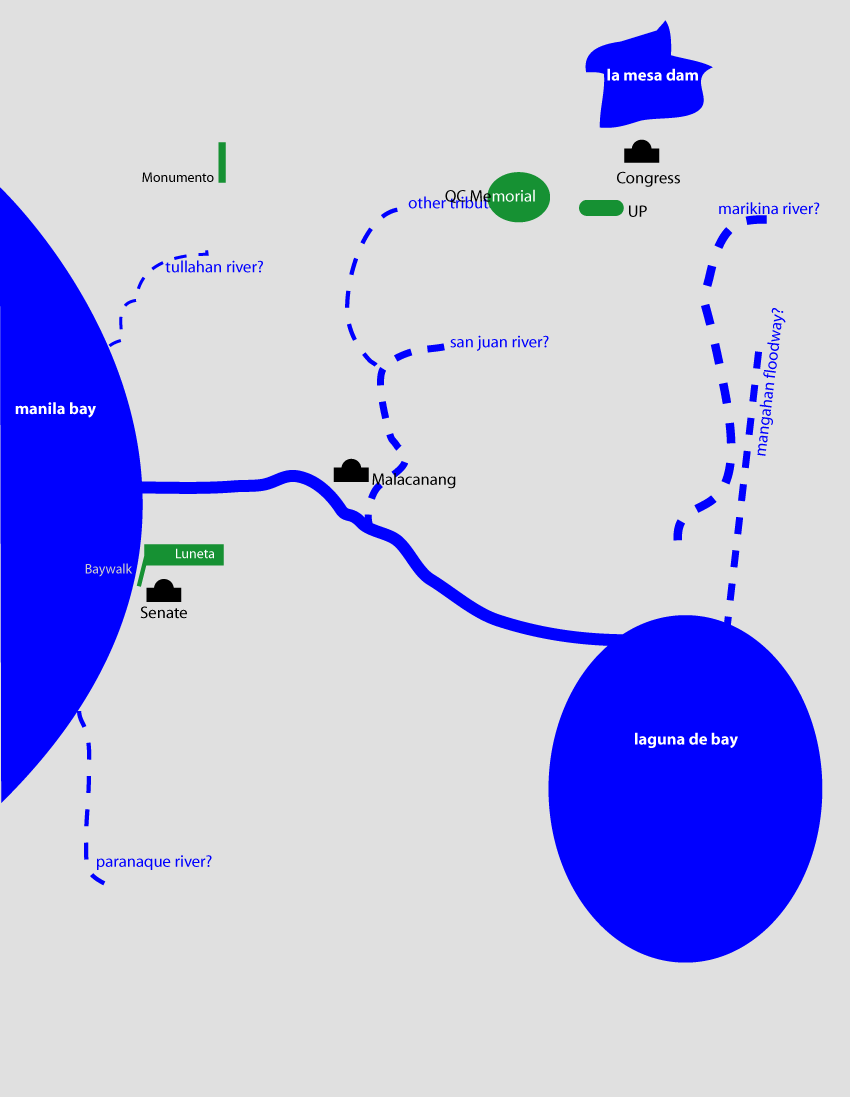
      above conceptual map of metro manila with
      suggested areas to celebrate the waterfront.


      below four opportunity sites at the confluence
      of the pasig and the san juan rivers


      (Cross posted from Another Hundred Years Hence)

      So how do we reconnect to our bay, our lake and our rivers? How do we bring them back into our shared imaginations of our cities?

      To do that, we have to celebrate our rivers, our lake and our bay. We have to celebrate them as places -and with places. Physical places where we can see and approach the water. Where the waters can reclaim their rightful place in our imagination.

      Fortunately for us, waterfronts offer some of the easiest areas for redevelopment -specially in old industrial cities.

      Cities all over the world have rediscovered and reinvested in their waterfronts. Check out False Creek in Vancouver, or London's Canary Wharf (also this), or Singapore's Boat Quay, or the Cambridgeside Galleria in Cambridge, Massachusetts -all of these were former decrepit industrial sites that were redeveloped by public and private funds, through the creation of innovative policy tools and investment vehicles.

      We've started on that road somewhat -with Marikina's Riverbanks, and Manila's Baywalk. Hopefully, the expansion of Rockwell into the old Noah's Ark Sugar factory property and the old Colgate-Palmolive factory will incorporate riverfront access. So too, I hope, Ayala's redevelopment of the Sta. Ana racetrack.

      If I had my druthers, I would turn the whole stretch of the pasig from the bay to the palace into a "riverwalk" -anchored on one end by the Intramuros and Fort Santiago and by Malacanang on the other -with the Arroceros Forest Park and a re-oriented Liwasang Bonifacio as gems in between. (Why hasn't anyone redeveloped Quiapo Ilalim?)

      I looked through Google Earth and identified at least 14 brownfield opportunity sites along the Pasig - notably at it's confluences with the San Juan and the Marikina -that are ripe for redevelopment. (Apart from the the manila oil depot -which really should move out of the city.)

      Four are right at in Sta. Ana and Sta. Mesa -on an interesting loop of land where the San Juan meets with the Pasig (see picture to the right). There are large swaths of land in Mandaluyong and Makati, along the banks of the Pasig near EDSA, and then even more right where the Marikina meets the Pasig. There are sites just east of C-5 and more south of Eastwood City (which, incidentally made the mistake of turning its back on the river.)

      I do not know how productive these properties are currently, but they would be great to redevelop into mixed-use, commercial, business and residential properties. The concerned cities should reassemble these lands - invest in the demolition and remediation (clear up any toxic messes) -then create public-private reinvestment companies to redevelop the sites. The tradeoffs (in return for the public investment) should be that the redevelop sites should set aside the waterfront for publicly accesible parks or public open spaces and that a percentage of the residential development should be affordable housing.

      I've posted the 14 sites I selected on Google Earth Philippines where you can download the kml file. Or you can view the sites via Google Maps.

      P.S.

      "What about the pollution?" you say. "Have you smelled the Pasig?" - Well one of the things we've discovered about redeveloping waterfronts -of placing parks next to the water -is that it only increases awareness and concern for the state of the rivers and lakes. The redeveloped sites become valuable opportunities (and venues) for educating the public about water -and the role it plays in our lives. (See this project in Chengdu, China.)

      The redeveloped sites could also be required to build in passive (or active) water treatment or bioremediation facilities such as living machines. (See also this example and this one.)

      (If you spot other places for redevelopment, send your kml file to Google Earth Philippines.)

      Saturday, July 08, 2006

      :: Five Roads I'd Like to Redesign

      There are at least 5 roads in Metro Manila that I'd like to re-imagine and redesign, namely:
      1. Commonwealth Avenue (R-7)
      2. Quezon Avenue / Espana (R-7)
      3. Ortigas Avenue (R-5A)
      4. Sucat Road
      5. Alabang-Zapote Road
      (Download the kml file via Google Earth Philippines. or view it on Google Maps.)

      There is so much we can do to make them work and look better -make them more pedestrian and bike friendly -and they will contribute to the a more livable urban environment.

      As wrote about rethinking our streets before, in Another Hundred Years Hence. (See also this and this.)

      What can these streets be? I've cribbed the great images from the Livable Cities presentation of the American Institute of Architect's Center for Community by Design (Get the powerpoint presentation here 1,792 KB - and the PDF here 1,769 KB).

      The pictures and text below are all from AIA. Click on the images for a larger version.

      Here you have a typical strip commercial development. This image is from Hawaii but it could be Anywhere. This is clearly a car-oriented landscape with narrow sidewalks, a wide roadway and buildings set far back.
      In this image, four key streetscape improvements have begun to change this to a pedestrian-oriented landscape.
      1. The sidewalks have been widened with landscape buffers to protect pedestrians from traffic;
      2. The buildings have been brought forward towards the sidewalk and retail has been added the first floors to create an interesting place for people to walk along;
      3. A bike lane has been added to the road to accommodate cyclists and provide another transportation choice;
      4. A median is included to reduce the perceived width of the road and facilitate pedestrian crossings.
      On the far side of the street, they’ve added mid-rise residential buildings with more retail on the ground floor. This mix of uses promotes neighborhood activity at all hours of the day.
      By adding trees and landscaping, the street becomes a pleasant, shady place to stroll. Also notice another building in the background has been added. Infill development helps to preserve urban centers.
      This image shows an alternative way to create a human-scaled street. Here, the bike lane is separated from thru-traffic and brought in with a local circulation lane for shoppers. The retail is still pedestrian-oriented and the angled parking serves a buffer from traffic.
      I see no reason why we can't do this. And we can argue about the effects this will have on traffic.

      For more images and like those above, visit Urban Advantage.

      Friday, July 07, 2006

      :: a river runs through it

      (Cross posted from Another Hundred Years Hence)

      Maynila
      was born on the banks of the Pasig -established by people who were taga-ilog ("river folk") and yet 600 years later, we are so disconnected from our bodies of water.

      Notice my conceptual map - I know the Pasig connects the Bay to the Lake and I know it runs north of Makati and South of QC, San Juan and Mandaluyong - but I am, as I suppose the majority of us are, not aware of its eastward route. I have no mental image of how it meets the Laguna de Bay.

      I have no mental image of the shores of the lake. I have a memory of driving around the lake -but not at the water's edge.

      I know the San Juan River and Marikina River feed into the Pasig -but also have no mental image of where these rivers meet. I know the Manggahan floodway separates from the Marikina River at the Napindan Floodgates -and the floodway then runs straight towards the bay. I also know that the Tullahan feeds into the Bay and somewhere down south, the Paranaque River also feeds the Bay.

      Why am I not aware of the paths of these rivers? Mainly because so few landmarks and public spaces are on the waterfront. Baywalk and the reclamation area face the bay. The Senate, the Cultural Center, the Folk Arts Theatre and the Coconut Palace are on the waterfront. So too the Quirino Grandstand in Rizal Park. The Malacanang is on the Pasig. The Jones, Macarthur, Quezon and the Ayala bridge over the river near Quiapo and Escolta.

      Apart from that, very little of our urban life is connected to the water. So the rivers are dead -not just biologically, but also in our imaginations. The rivers do make their presences felt when they overflow their banks.

      There are efforts to revive the Pasig and the return of the ferry will help -but until we reclaim the waterfront as public space, our waterbodies will live outside our conception of our metropolis.

      (You can download a kmz file of the metro's major rivers on Google Earth Philippines or you can view it on Google Maps.)

      Thursday, July 06, 2006

      :: Mass Transit I'd Like to See

      Here's something I'd like to see QC take on as a city project: a series of bus rapid transit / or tram (surface light rail) lines connecting employment and commercial centers in the city.
      Click on the picture for a larger image, or see it on Google Maps. You can also download the kml file from Google Earth Philippines, via this link.
      I've chosen mostly wide roads on routes that are not directly served by (a single) jeep or bus route.)
      I see at least 4 lines.
      1. RED - UP to Quiapo via Quezon Ave. and Espana (potentially the most politically difficult because of exisiting jeep and bus routes -and the planned LRT line 7 -but I think QC should go ahead with it anyway)
      2. BLUE - From North Triangle to UP via Ortigas CBD and Eastwood/Libis
      3. YELLOW- Cubao to Eastwood/Libis Loop
      4. GREEN - Cubao to Munoz via Congressional and Visayas Avenues.
      These should preferably be on dedicated lanes and fixed tracks -but at grade. Narrower roads can be reserved for exclusive use of the bus/trolleys (except for local residents).
      Pictures below show what they could look like.
      (Check out my latest post at Another Hundred Years Hence to see the logic behind these connections.)